The information on this page was correct at the time of publishing (December 2022). The project has since evolved and we would encourage you to read our September update for more information.
North Falls: offshore
Offshore array
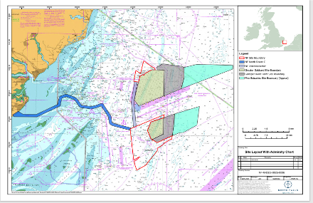
Like our sister project Greater Gabbard, the North Falls offshore array area is split into two separate sections, with boundaries to take the existing shipping route into account. The site boundaries have not changed since our previous consultation.
It will be within the two boundaries that turbines, array cables and offshore substation(s) will be installed. The northern section covers approximately 20km2 and is 22.5km from shore at its closest point. The larger southern section covers approximately 130km2 and is 38km from shore at its closest point.
There will also be an interconnector running between the northern and southern sections.
Offshore infrastructure
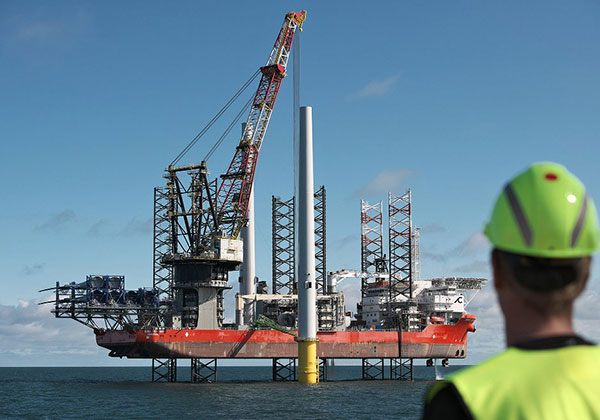
North Falls will use conventional three bladed, horizontal axis turbines made up of a: rotor, comprised of blades, a hub and a nacelle housing the generator and electronics, and a tubular steel tower. The layout of the wind turbines will be defined post consent and will take into account wind resource, ground conditions and the turbines chosen. However, at this stage we can state that the minimum spacing between turbines would be 820m.
Like the turbines, the number and type of foundations will be finalised post-consent and following detailed design.
North Falls will require up to a maximum of two offshore substations depending on the electrical system voltage and final layout. These comprise a platform topside supported by a foundation.
A total of up to 228km of high voltage alternating current (HVAC) cables will link the turbines to the offshore converter station(s). The project design also includes an interconnector cable between the northern and southern array areas.
up to 72
Number of turbines
820m
Minimum distance between turbines
1 or 2
Number of offshore substations
228km
Total length of array cables
55km
Length of export cables
range from 5m to 59m
Water depths within the array sections
Export cable corridor
The electricity generated by North Falls will be transmitted to shore by from the offshore substation(s) via export cables which will be located within an offshore export cable corridor. Through our planning work we have identified a proposed corridor to run from the southern array area to a proposed landfall on the Essex coast near Frinton-on-Sea.
The offshore export cable corridor passes to the north, and outside of the Margate and Long Sands Special Area of Conservation (SAC) and Kentish Knock East Marine Conservation Zone (MCZ), with a small overlap with the Outer Thames Estuary Special Protection Area (SPA) as it approaches landfall.
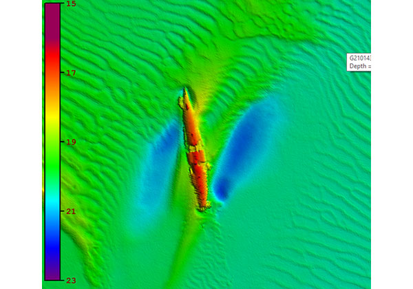
A number of constraints have been considered in the routing of the provisional offshore export cable corridor including: engineering feasibility; nature conservation designations; other offshore wind farms; shipping and navigation; dredging areas; existing infrastructure and wrecks. In additional to general shipping and navigation we have also taken into consideration other specific sea users in particular: fishing activity, aggregate and military use.
Offshore construction
Pre-construction seabed surveys will be undertaken along with work such as boulder removal to prepare the array site and cable route for construction of the wind farm. The construction methodologies used will depend on the final design, seabed condition and type of technology or component selected. These will be decided post-consent, with the full range of options to be included in the development consent order application.
Feedback Questions
The feedback from this question primarily related to minimising impacts on marine life and the offshore ecosystem, with a specific focus on being aware of cod spawning sites near the offshore site. Some respondents felt the project's presence may help reduce the likelihood of overfishing. There were some suggestions around use of recyclable turbine blades, some generally supportive feedback and one comment around using an alternative sub-sea connection that comes to land elsewhere.